
Over the past 40 years the district’s coal mining heritage has often featured in my work. However, when something is so large, the scale so incomprehensibly vast and its importance so immeasurable to the district’s communities, it becomes challenging to depict it. To be honest, if someone asked me to point out where coal mining took place on a map of the Wakefield District I would just point at the whole district and say ‘there’.
With such complex ideas to explore, I tend to start with personal stories.
When I was a child, I would catch the bus from Ackworth to Pontefract. Just outside the village, the bus would stop at a coal mine and the bus would fill up with miners, complete with their helmets and head torches. That memory has always stayed with me.
Many years later, in 2018, I created a map of the Wakefield District showing the sites of coal mines based on people’s memories and recollections. I mapped about 60 mines, including the one from my own memories at Ackworth. It soon became clear that there were disagreements about the exact locations of these mines. For example, many people were adamant that there wasn’t a coal mine in Ackworth and I began to doubt my own memories.
In 2022 I decided to attempt another map titled Coal Table. This time, I wanted a more reliable source of information for the locations of the collieries, rather than rely on memory and recollection. Luckily such a source exists in the excellent book ‘Yorkshire Collieries 1947 – 1994’ by Eddie Downes. Using this book, I identified 34 collieries that existed in the Wakefield district from when the industry was nationalised in 1947 until the last colliery closed in 1994.
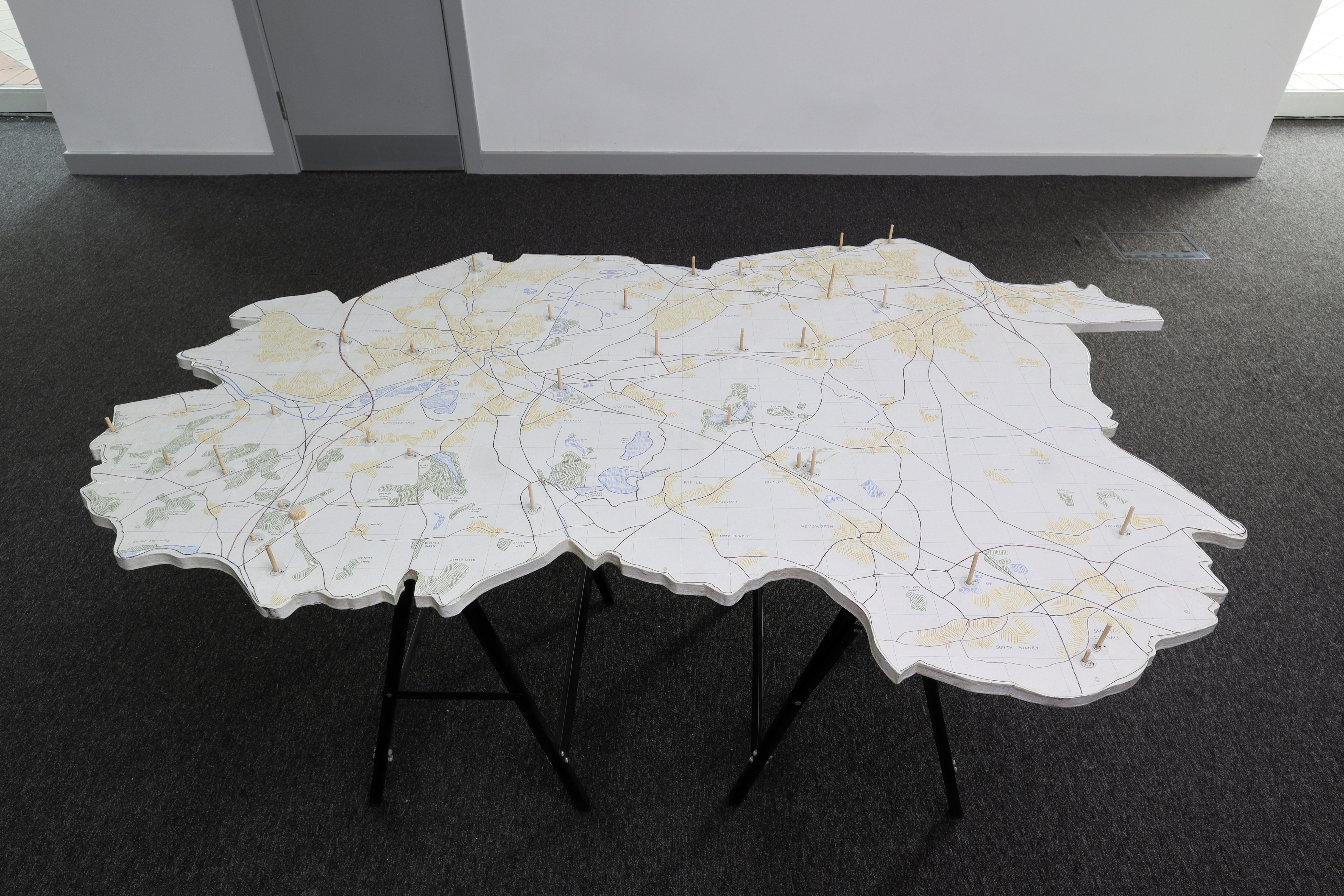
The Coal Table map was a sculpture that took the form of a table. The top was the shape of the Wakefield district at a scale of 1:16,000 and was marked with roads, towns and colliery locations. Each colliery was represented by a piece of dowel, the length of which was in proportion to the depth of the colliery’s deepest shaft (at the same 1:16,000 scale). For drift mines, I calculated the depth based on the degree and length of the incline.
It was quite staggering how deep some of the mines were (remember how the chimneys at Ferrybridge Power Station used to dominate the district’s skyline? Imagine those, below the surface and times that by 3.5).
A colliery could be a very large site with many pit heads, headstocks (winding gears), and shafts. Many of the 60 mines that I had originally mapped in 2018 were actually part of these 34 collieries. The coal mine that I remembered, just outside Ackworth, did exist, but it was part of Ackton Hall Colliery in nearby Featherstone.
Another consideration was that Wakefield District came into being in 1974. Many miners from the district worked at collieries just over the boundary, (for example, miners from Havercroft and Ryhill would work at Monkton Main Colliery, a couple of miles away in Barnsley, though New Monkton No.5 Shaft was within the Wakefield District boundary).
With all this in mind, I developed the initial ideas behind the visuals for Coal Lines.
I once more plotted the locations of the 34 collieries on Ordnance Survey maps of the Wakefield District. The maps and locations are on the display boards.
These are the 34 collieries.
| 1 | Ackton Hall | 18 | Newmillerdam (Drift) |
| 2 | Bullcliffe Wood (Drift) | 19 | Nostell |
| 3 | Caphouse | 20 | Old Roundwood |
| 4 | Crigglestone | 21 | Park Hill |
| 5 | Denby Grange | 22 | Prince Of Wales |
| 6 | Frickley | 23 | Sharlston |
| 7 | Fryston | 24 | Snydale |
| 8 | Glasshoughton | 25 | South Elmsall |
| 9 | Greatfield | 26 | South Kirkby |
| 10 | Haigh | 27 | St Johns |
| 11 | Hartley Bank | 28 | Upton |
| 12 | Hemsworth | 29 | Walton |
| 13 | Kinsley (Drift) | 30 | West Riding |
| 14 | Lofthouse | 31 | Wheldale |
| 15 | Manor Haigh Moor | 32 | Whitwood |
| 16 | New Monkton (part of Monkton Main) | 33 | Woolley |
| 17 | Newmarket | 34 | Woolley Edge |
I scaled a map of the Wakefield District to fit on one-half of the floor of WX and plotted the 34 colliery sites in relation to each other to indicate their locations. I like to think of this as being similar to a star map, charting the constellation of collieries.
Using photographs from NCMME, local ex-coal miners, and many coal mining groups for reference, I drew silhouettes of one of the headstocks from each colliery; no two were the same. For the drift mines, I drew a different piece of mining machinery.
23 of the 34 colliery sites in Coal Lines are illuminated. These are the 23 collieries that were still operational when the Wakefield District was formed in 1974.
Once this was done I wondered if it was possible to use the different depths of the collieries to create a tune, giving each colliery a note; the deeper the mine, the lower the note.

